
The Piri Reis Map: A Mysterious Map Ahead of Its Time
The Piri Reis Map: A Mysterious Map Ahead of Its Time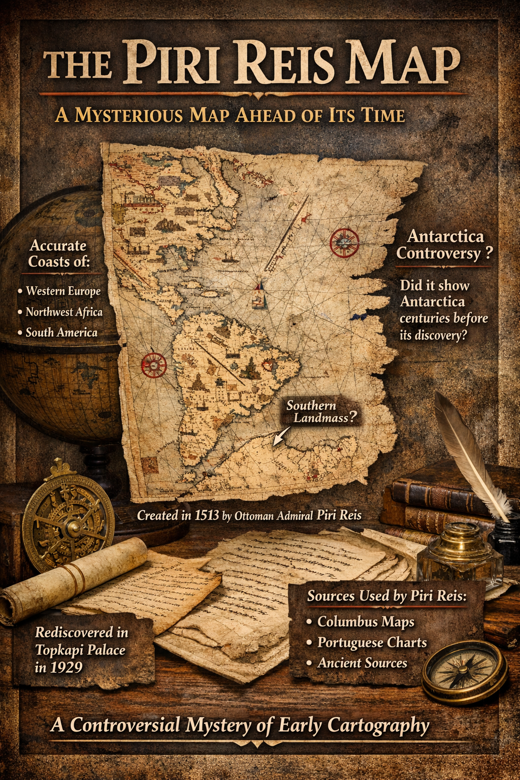
Introduction
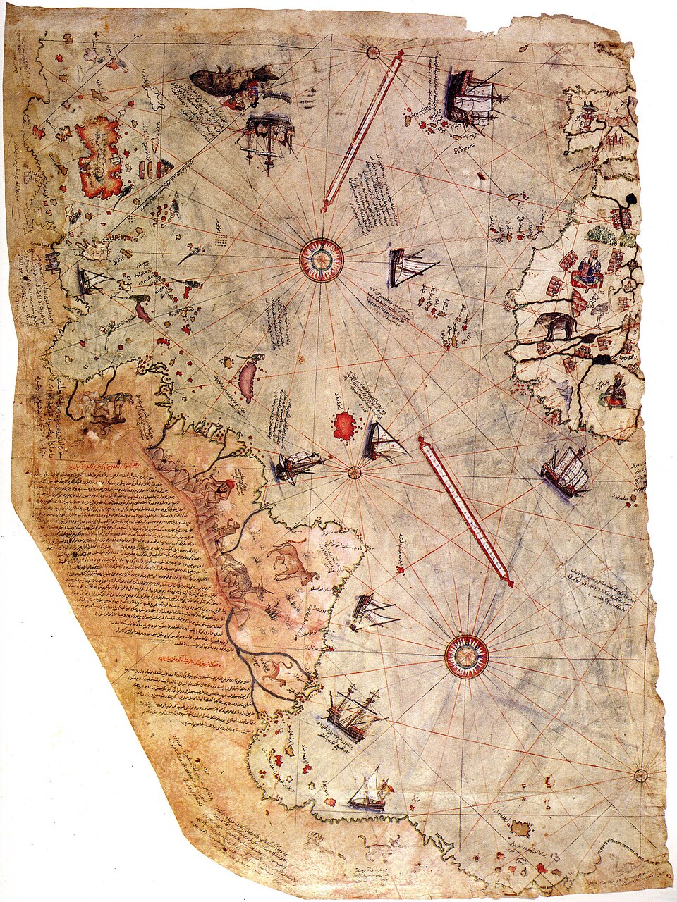
In the early 16th century, an Ottoman admiral created a world map that continues to puzzle historians and scientists today. Known as the Piri Reis Map, the map appears to show remarkably detailed coastlines of parts of Europe, Africa, and the Americas—at a time when much of the world was still unexplored.
Some researchers even claim the map may depict parts of Antarctica centuries before its official discovery, making it one of the most controversial artifacts in cartographic history.
Discovery of the Map
The map was rediscovered in 1929 inside the Topkapı Palace, one of the historic palaces of the Ottoman Empire.
Scholars examining old documents found a fragment of a large world map drawn on gazelle skin parchment. The map was signed by Piri Reis, who completed it in 1513.
Only about one-third of the original map survives today, but even this fragment has generated enormous debate among historians.
What the Map Shows
The surviving portion of the Piri Reis Map includes detailed coastlines of:
-
Western Europe
-
Northwest Africa
-
Parts of South America
-
Islands of the Atlantic Ocean
The map also contains notes written by Piri Reis explaining his sources. According to his annotations, he used more than 20 different maps and charts while compiling his work.
Some of these sources may have included maps created during the voyages of Christopher Columbus, whose journeys had recently revealed the Americas to Europe.
Why the Map Is So Mysterious
The Piri Reis Map stands out because of the unexpected accuracy of certain coastlines.
Some researchers claim that the map shows:
-
Surprisingly accurate shapes of the South American coastline
-
Geographic features that were not well known in the early 1500s
-
A southern landmass that some believe resembles Antarctica
The last point is especially controversial because Antarctica was officially discovered in 1820, more than 300 years after the map was created.
The Antarctica Controversy
In the 20th century, some authors suggested that the southern section of the map might represent Antarctica without its ice cover.
These claims became popular in alternative history books, which proposed that the map might be based on much older, lost sources from ancient civilizations.
However, most modern historians and geographers disagree. They argue that the supposed Antarctic coastline is likely a distorted representation of South America, drawn with limited geographic knowledge.
Sources Used by Piri Reis
In his own notes, Piri Reis explained that he compiled the map using several earlier charts. These likely included:
-
Portuguese exploration maps
-
Arab and Islamic geographic charts
-
Maps from Christopher Columbus’s voyages
-
Classical sources from ancient scholars
This combination of information may explain why the map appears more detailed than other maps from the same period.
A Masterpiece of Early Cartography
Despite the controversies, historians widely agree that the Piri Reis Map is an extraordinary achievement in early cartography.
It reflects the rapid expansion of geographic knowledge during the Age of Exploration, when sailors were discovering new lands and bringing back valuable information for mapmakers.
Today, the map is preserved in Topkapı Palace Museum in Istanbul, where it remains one of the most famous historical maps in the world.
Conclusion
More than 500 years after its creation, the Piri Reis Map continues to fascinate historians, geographers, and mystery enthusiasts.
Whether it simply reflects the best knowledge of early explorers or contains traces of lost geographic information from older civilizations, the map remains a powerful reminder of humanity’s long quest to understand and chart the world.